Home Up


ALBAY 1ST


Source: RBIA Database                              Unit of Measure: kilometer (km) 
DEO / Functional Classification / Road Name / Road Number  Condition Rating   Grand Total 
 Good   Fair   Poor   Bad   No Assessment 
  Secondary Roads            7.22            9.38          8.84          32.37         3.67           61.49
1 Daang Maharlika Jct-Legazpi-Sto Domingo-Tabaco-Camarines Sur Bdry Rd            3.91            3.56          5.82          29.94         2.51           45.74
  Concrete             0.23             0.23           0.26             4.95          0.97              6.64
  Asphalt             3.68             3.33           5.57            24.99          1.54             39.10
2 Ligao-Tabaco Rd            1.84            5.82          3.02            2.43         1.16           14.27
  Concrete             0.32             0.10           0.41             1.16          0.21              2.19
  Asphalt             1.52             5.72           2.61             1.28          0.95             12.08
3 Tabaco Wharf Rd            1.48                -                -                  -           0.01             1.49
  Asphalt             1.48                -                -                   -            0.01              1.49
  Tertiary Roads            9.18            3.50          3.15          21.55         0.55           37.93
A Malinao Poblacion Rd                -              0.51              -                  -               -               0.51
  Asphalt                -               0.51              -                   -               -                0.51
B Mt Mayon Park Rd            3.93            2.19          2.06            0.20         0.16             8.54
  Concrete             0.43             0.43           1.69             0.20          0.12              2.87
  Asphalt             3.50             1.76           0.36                 -            0.04              5.67
C Sto Domingo Poblacion Rd            2.41            0.80          0.81            0.81         0.04             4.88
  Asphalt             2.41             0.80           0.81             0.81          0.04              4.88
D Sto. Domingo-Buhatan-Cagraray Circumferential Rd            2.84                -            0.28          20.54         0.35           24.00
  Asphalt             2.84                -             0.28            20.54          0.35             24.00
TOTAL          16.40          12.89        11.99          53.92         4.22           99.42


Source: RBIA Database      
Road Name / Section ID Route Numbering Start KM End KM
Daang Maharlika Jct-Legazpi-Sto Domingo-Tabaco-Camarines Sur Bdry Rd      
S03684LZ 630 K0540 + (-936) K0584 + 847
Ligao-Tabaco Rd      
S03651LZ 636 K0516 + (-844) K0527 + 975
S03656LZ 636 K0528 + (-046) K0529 + 493
Malinao Poblacion Rd      
S03659LZ      
Mt Mayon Park Rd      
S03031LZ      
S03705LZ   K0517 + (-095) K0525 + 525
S03720LZ      
Sto Domingo Poblacion Rd      
S03718LZ   K0541 + (-100) K0546 + 182
S03719LZ      
Sto. Domingo-Buhatan-Cagraray Circumferential Rd      
S03730LZ   K0543 + 000 K0567 + 000
Tabaco Wharf Rd      
S03657LZ 637    
S03658LZ 637    

Home Up Next


Albay 1st / Albay 2nd / Albay 3rd / Camarines Norte / Camarines Norte-Sub / Camarines Sur 1st / Camarines Sur 2nd / Camarines Sur 3rd / Camarines Sur 4th / Camarines Sur 5th / Catanduanes / Masbate 1st / Masbate 2nd / Masbate 3rd / Sorsogon / Sorsogon 2nd

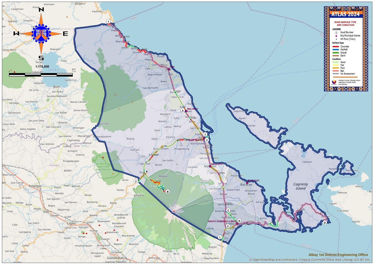
Notes:
 

1.) Road data provided are as of  16 October 2024.

2.) The unit of measure for Road Data is kilometers.

3.) No Assessment refers to Road Sections that are either under construction and/or segments with length below the 50-meter gauging length.

4.) National Roads are classified into:

 Primary Roads - A contiguous length of significant road sections extending linearly without any breaks or forks that connect major cities (At least around 100,000 population) comprising the main trunk line or the backbone of the National Road System.   

 Secondary Roads - Directly connect cities to national primary roads (except in metropolitan areas) or those not included in the category of major cities. Likewise, said roads directly connect major ports, major ferry terminals, major airports, tourist service centers, major government infrastructure to national primary roads. They also directly connect provincial capitals within the same region.

Tertiary Roads - Other existing roads under DPWH which perform a local function. (In the map, these roads are represented only by letters.)


For questions regarding this Website contact feedback@dpwh.gov.ph


Last updated: 02/27/25.

Disclaimer